Saltar al contenido
Cityweft
Abrir
Blog

Últimas publicaciones

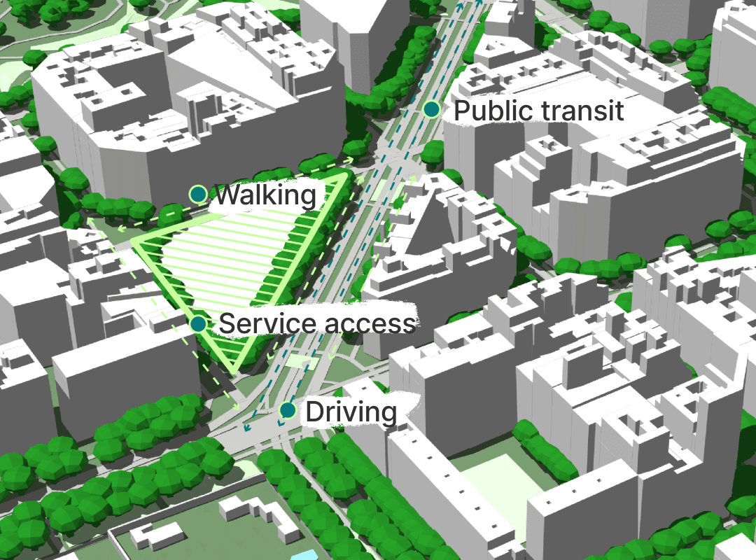
Novedades del producto, profundidad en la pipeline y cómo los equipos AEC usan el contexto 3D del emplazamiento.

13 abr 20263 min de lectura

Japan Nationwide LOD2 Building Data | Cityweft 🇯🇵

Cityweft now offers nationwide LOD2 3D building data for Japan, covering ~26.8 million buildings across 266 datasets. Generate accurate 3D city models for Tokyo, Osaka, Yokohama, Kyoto, and more with detailed roof geometry and building heights. Export ready-to-use models for architecture, planning, visualization, and digital twins via the Cityweft platform, plugins, or API.

Leer más
2 abr 20263 min de lectura

Introducing: A Cityweft Plugin for SketchUp

The Cityweft SketchUp Plugin lets architects import 3D site, context, and city models directly into SketchUp. Fully editable and layered, models integrate seamlessly into projects, enabling real-world context, massing studies, and early-stage design without leaving SketchUp. Quickly search, select, and generate accurate city models to speed workflows and improve architectural decisions.

Leer más
18 mar 20264 min de lectura

Georeferencing in Cityweft: an early step toward smoother BIM coordination

Georeferencing in Cityweft helps architects and design teams align BIM models with real-world coordinates, reducing coordination errors, misalignment, and time spent fixing clashes. By embedding WGS84-based location data while keeping models lightweight, it enables smoother collaboration across disciplines and more reliable BIM workflows.

Leer más
5 mar 20264 min de lectura

Germany Nationwide LOD2 Building Data | Cityweft 🇩🇪

Cityweft now includes nationwide LOD2 3D building data for Germany, aggregated from official German state geospatial authorities. Generate detailed, high-accuracy city models with realistic roof geometries and building heights, improving urban context for design, planning, and analysis. The dataset is available across the Cityweft platform, plugins, and API, enabling a seamless workflow for projects anywhere in Germany. 🇩🇪

Leer más
23 feb 20262 min de lectura

New Surface Modes in Cityweft: More Control, More Clarity, Better Context

Cityweft Model from San Francisco with Raster Map and Satellite Surfaces 3D buildings are essential for understanding a site, but they are only part of the story. To truly understand how structures interacts with its surroundings, you also need to understand the ground it sits on. Surfaces influence how people move, how buildings relate to streets and landscapes, and how projects affect mobility, accessibility, and the urban environment around them. With our latest update, Cityweft expands...

Leer más
26 ene 20262 min de lectura

Cityweft x Graphisoft: Bringing Local Context into a New Era of Design Intelligence

We’re excited to announce a new collaboration between Cityweft and Graphisoft , focused on bringing accurate, real-world site context directly into Graphisoft’s next-generation design intelligence tool. Together, we’re working to help architects make smarter, more confident decisions - from early feasibility through to delivery - by ensuring that buildings and topography are not add-ons, but a natural starting point for design. Grounding design in real context Graphisoft’s new tool expands...

Leer más
19 ene 20262 min de lectura

Data Update Norway 🇳🇴: New National LiDAR Building Data

Cityweft provides a nationwide dataset of 3D building heights for England based on high-precision airborne LiDAR data collected by the UK Department for Environment, Food & Rural Affairs (DEFRA) between 2022 and 2025. Building heights are measured from real elevation data, not inferred estimates. Coverage includes urban and rural areas and supports architectural design, urban planning, environmental analysis, and simulation via Cityweft’s platform, plugins, and API.

Leer más
19 ene 20263 min de lectura

Data Update Canada 🇨🇦: New National LiDAR Building Data

Cityweft provides a nationwide dataset of 3D building heights for England based on high-precision airborne LiDAR data collected by the UK Department for Environment, Food & Rural Affairs (DEFRA) between 2022 and 2025. Building heights are measured from real elevation data, not inferred estimates. Coverage includes urban and rural areas and supports architectural design, urban planning, environmental analysis, and simulation via Cityweft’s platform, plugins, and API.

Leer más
8 ene 20263 min de lectura

Spain LiDAR Building Heights (IGN) | 3D Building Data in Cityweft

Cityweft provides a nationwide dataset of 3D building heights for England based on high-precision airborne LiDAR data collected by the UK Department for Environment, Food & Rural Affairs (DEFRA) between 2022 and 2025. Building heights are measured from real elevation data, not inferred estimates. Coverage includes urban and rural areas and supports architectural design, urban planning, environmental analysis, and simulation via Cityweft’s platform, plugins, and API.

Leer más
7 ene 20263 min de lectura

Data Update Denmark 🇩🇰: New National LiDAR Building Data

Cityweft provides a nationwide dataset of 3D building heights for England based on high-precision airborne LiDAR data collected by the UK Department for Environment, Food & Rural Affairs (DEFRA) between 2022 and 2025. Building heights are measured from real elevation data, not inferred estimates. Coverage includes urban and rural areas and supports architectural design, urban planning, environmental analysis, and simulation via Cityweft’s platform, plugins, and API.

Leer más
22 dic 20255 min de lectura

Cityweft vs. OSM-Based 3D Models

Looking for an alternative to OSM-based 3D city models? Cityweft is built for architects who need complete, exportable 3D site context —with building heights, roofs, terrain, and richer datasets than OpenStreetMap alone. It’s the fastest way to go from open data to a usable 3D city model for design . Try Cityweft → From Open Data to Complete City Context Architects use 3D city models to make decisions about massing, height, daylight, views, and urban fit. Those decisions depend on how...

Leer más
16 dic 20254 min de lectura

Advanced workflows with the Cityweft Rhino & Grasshopper plugin

Diving into advanced workflows using Cityweft's Grasshopper plugin for Rhino

Leer más
15 dic 20252 min de lectura

LiDAR-based 3D Building Data for England 🏴󠁧󠁢󠁥󠁮󠁧󠁿

Cityweft provides a nationwide dataset of 3D building heights for England based on high-precision airborne LiDAR data collected by the UK Department for Environment, Food & Rural Affairs (DEFRA) between 2022 and 2025. Building heights are measured from real elevation data, not inferred estimates. Coverage includes urban and rural areas and supports architectural design, urban planning, environmental analysis, and simulation via Cityweft’s platform, plugins, and API.

Leer más
3 dic 20252 min de lectura

Switzerland 3D Building Data (swisstopo LOD2) | Cityweft🇨🇭

Cityweft now includes swisstopo’s full 3D LOD2 building dataset, delivering detailed, high-accuracy models across Switzerland. Enjoy richer roof geometries, improved urban context, and more precise analysis for design, planning, and visualization. The data is available on the platform, plugins, and API for a seamless, high-fidelity workflow nationwide.

Leer más
2 oct 20252 min de lectura

Cityweft API Brings The Best Global Site Data To Podium.io

We’re excited to share our new collaboration with Podium.io , who have recently integrated the Cityweft API into their platform. This...

Leer más
29 sept 20253 min de lectura

26/09/25 Update: New Local Building Data for Central Europe!

We’re excited to announce the latest update to our data sources, bringing in a wealth of localized, high-quality building data from...

Leer más
9 sept 20252 min de lectura

08/09/25 Update: Real-World Shadows, Landmark Models, and New Pricing Bundle

At Cityweft, we’re constantly evolving to make working with 3D city models faster, smarter, and more useful in real-world design...

Leer más
8 sept 20254 min de lectura

Where to Get Global 3D City Models with Buildings, Topography, and Infrastructure for CAD/BIM Workflows

Introduction Architects, planners, and designers often need detailed 3D city models that go beyond rough massing. Global coverage,...

Leer más
26 ago 20253 min de lectura

Cityweft at AEC Tech+ Barcelona: Real-World Context in Minutes

Earlier this summer, Cityweft partnered with the AEC Tech+ Hackathon in Barcelona , hosted by CORE studio at Thornton Tomasetti , McNeel...

Leer más
19 ago 20253 min de lectura

Cityweft Expands Free Access to High-Quality 3D City Models

Cityweft model of New York, rendered with Rhino/Enscape Over the past few months, the Cityweft platform has been growing at full speed....

Leer más
29 may 20243 min de lectura

CADMAPPER vs Cityweft

High-quality cityscape 3D models are essential for accuracy and realism in urban modeling, city planning, and other areas. Cityweft...

Leer más